Ask NASA Climate | February 18, 2010, 16:00 PST
State of Flux
Spot the difference
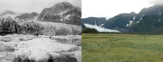
Pedersen Glacier, Alaska. Left: 1917. Right: 2005. Credits: 1917 photo captured by Louis H. Pedersen; 2005 photo taken by Bruce F. Molnia. From the Glacier Photograph Collection, National Snow and Ice Data Center/World Data Center for Glaciology.
That’s why we’re launching a brand spanking new image gallery, called State of Flux. Each week we’ll be featuring time-lapse images of different locations on planet Earth, showing change over time periods ranging from centuries to days. The pictures come from a range of intrepid explorers: Victorian photographers, astronauts on the International Space Station and NASA satellites taking snapshots of the Earth.
We start with Pedersen Glacier in Alaska, which has retreated significantly since the beginning of the 20th century. Enjoy and be sure to check back for new and stunning images of change.